Airborne Geophysical Survey
Frequently Asked Questions for the Community
Information for the community
Chances are that you're on this page because you have been notified that a plane is surveying your area and maybe you have some questions. We hope the information provided is useful. If you cannot find what you are looking for, we welcome you to reach us at info@bellgeo.com.
Who is flying the survey?
The survey will be managed and flown by Bell Geospace.
Bell Geospace are a UK-based company with an office in Edinburgh, Scotland. Bell Geospace owns and operates three aircraft which have been especially modified for geological mapping. The company has over twenty-five years experience in geophysical surveys and a wide variety of experience across many countries and conditions. There will be one aircraft will be operating on the survey in Cornwall.
Why is a survey taking place?
The purpose of the survey is to collect geophysical information on the properties of the rocks below the ground.
By carrying special technology onboard, the Bell Geospace aircraft is able to sense and measure geological properties which cannot otherwise be seen. Essentially, we are able ‘see’ through to the Earth’s subsurface.
The survey in Cornwall is collecting information to make geological maps. These maps may be used for evaluating the geothermal energy and lithium potential in the Cornwall area. Lithium is considered a critical mineral, needed to meet net-zero economic goals.
The information collected will be used as a part of a wider consideration on future steps for activities in the area. Data acquisition does not represent any excavation activity. Bell Geospace is not a mining company.
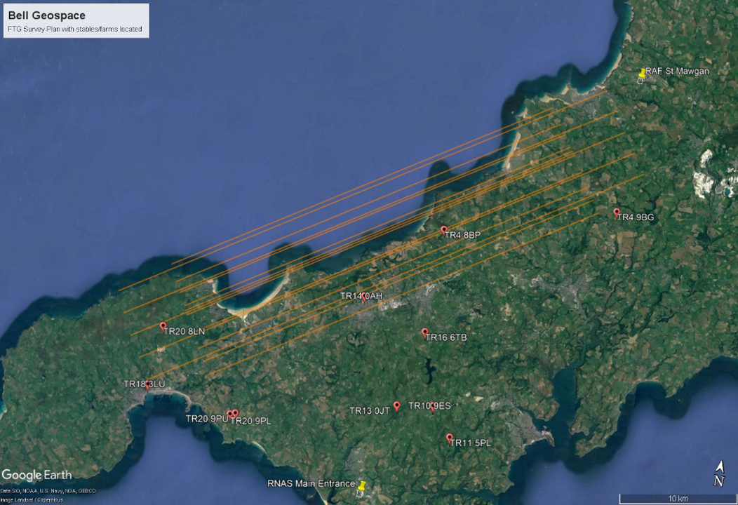
What is the location of the survey?
Please refer to the map which shows the flight lines planned for March.
Pins show horse owners/farms who are currently signed up for notifications of surveys.
map source Google Earth
-
Please provide more details on the flight
The plane will fly at a minimum height of 100 meters, increasing to 300 meters over urban areas. The flight lines will generally be spaced at 200 meter intervals.
Each flight line generally is only flown once. On infrequent occasions flight lines are repeated but it is rare to ever be flown more than two times.
What is being measured?
We are using gravity signal readings to measure changes in density.
We are looking for the minute changes in Earth's density distribution in all directions (tensors) – the measurement is known as Eötvös.
The instrument used to collect the information is known as a gradiometer, which is the size of an average washing machine. It holds technology called accelerometers. Accelerometers can also be found in your mobile phone. The accelerometers are on plates placed at opposing angles and then placed inside an umbrella shape to get the measurements that we need.
When will flights take place?
Flights will take place daily, each morning.
Flights tend to take place in the morning. Starting from around 8am. We expect to be flying for up to five hours per day.
Flights may continue on weekends. We expect to be flying for one week from 04/03/2022.
Inclement weather (excessive wind, storms, clouds) can cause flight delays, as can unforeseen circumstances such as unannounced military practice or unexpected wild animal/bird activity.
What is the aircraft being used?
The Basler BT-67 is an ideal plane for this job.
Bell Geospace required a plane with two engines for added safety, low sensitivity to turbulence for improved data quality, a strong track record of reliability, and good endurance for increased international reach. The Basler BT-67 met these requirements. The BT-67 is a converted DC-3 aircraft fitted with twin turboprop engines and state-of-the-art digital avionics. It combines excellent productivity with logistical efficiency.

Should I have any concerns?
The survey is safe and is an entirely passive process.
Neither the technology on the aircraft, nor the aircraft send out any signals or booms into the Earth.
Information is collected by measuring gravity and derivatives of gravity (which is known as gradiometry). It is an entirely passive process.
Livestock/horse owners can follow on our facebook page and we are also posting updates on the facebook page run by Equestrian Cornwall
Bell Geospace has an unblemished safety record.
- The Bell Geospace Operations team monitors and mans the aircraft continuously when the aircraft is not parked
- Local Air Traffic Controllers (ATCs) and Air Defence Control (IAF) always know where the aircraft is located
- Bell Geospace is an Active member of IAGSA (International Airborne Geophysical Safety Association https://www.iagsa.ca)
- The Aircraft in use (BT-67) has been chosen and modified to be the safest and most reliable aircraft possible for the job
Can I get more information?
Yes, of course. If you have questions please email us at info@bellgeo.com or call our community helpline 0131 202 7144.
Livery yard managers and farmers with any concerns are welcome to get in touch. We can arrange to notify you ahead of time.