The demand for critical metals to support modern society and the transition to more sustainable future development is expanding, and thus, both sector growth and responsible exploration are imperative. Mineral exploration in Canada presents a vast opportunity to continue contributing towards the development of a substantiable future society, both domestically and internationally, as well as providing substantial economic benefits to Canada. Nonetheless, responsible exploration requires accurate determination of the detailed geometries, location, and dimensions of prospective deposits, to facilitate their extraction whilst minimising environmental repercussions.
The Bathurst Mining Camp (BMC) in New Brunswick, Canada serves as useful template for the design of exploration strategies. This is a region of highly deformed rocks that hosts one of Canada's most important base metal mining districts. While further economic mineral potential exists in the region, efficient exploration requires advancements in the understanding of the regional geological evolution. As such, the objective of this project is to constrain the distribution, geometries, location, and dimensions of ore-bearing formations in the BMC as well as their evolution through time.
The steps of this project provide predictive models for use by exploration companies that will lead to greater exploration success in the region and provide a case example from the BMC demonstrating the applicability of FTG data to such problems elsewhere.
Project Stages
1. Conduct a regional-scale lineament analysis of the BMC using Full-Tensor Gradiometry (FTG) and topographic datasets
2. Conduct 3D inversions of FTG data for sub-surface density, and
3. Integrate the results of the 3D inversions and lineament analysis to establish key data signature patterns that are diagnostic of specific ore-bearing geological features to constrain the timing, geometry, and kinematics of deformation-related mineralization

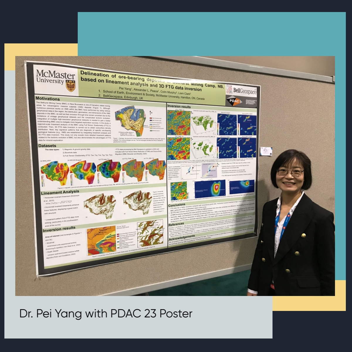
At PDAC 2023, Pei presented a summary from the first part of her research. Following completing lineament processing over the whole area, a small area of interest was used for the inversion testing. The image above shows some images taken from the poster. The entire poster is available to view here.
Part 1 : lineament mapping with FTG tensor components
Geological lineaments are widespread, occur on a complete range of scales, and are generally considered to represent the surface expression of subsurface structures of various origins (Richards, 2000). For this reason, they are useful to extract from geoscientific datasets to elucidate geological evolution and structures. Lineaments are commonly difficult to observe on the ground and are therefore most easily identified from satellite imagery and potential-field geophysical data (Yeomans et al., 2019). It has been shown that regional lineament detection for mapping of geological structure can provide crucial geoscientific information, including for mineral exploration (Manuel et al., 2017; Yeomans et al., 2019; Forson et al., 2021).
The FTG tensor components Txz and Tyz were used to calculate lineaments for a regional-scale lineament analysis. The lineaments identified from both tensor components considerably enhance linear features of the BMC, displaying a good match with regional-scale faults. In particular, more striking linear patterns in the southwestern region (e.g., the Stratmat and Heath Steele) of the survey can be seen.
In the Heath Steele area, the lineament patterns calculated from Txz and Tyz components are in a good agreement with positive magnetic anomalies.
In the Stratmat area, the calculated lineament pattern has a good match with the interpreted Stratmat fault.
Part 2 : Unconstrained FTG data inversion in the Stratmat and Heath Steele areas
According to the calculated lineaments and relatively recent drilling sites, the Stratmat and Heath Steele areas located in the southwestern region of the BMC are chosen as the area of interest for geophysical inversion test.
Inversion results from FTG gravity data inversion appear to be geologically reasonable and largely consistent with existing geologic understanding and drilling sites.
Lenses of potential massive sulfide are widespread in both the Stratmat and Heath Steele areas and some of these lenses may be associated with mafic intrusives. The major mineralized zones appear to distribute within or around the edge of high-density zones in the Stratmat area.
Results indicate high-resolution 3D FTG datasets have a striking advantage of delineating exploration targets in the region within complicated structure and less drilling sites.
Keep following Bell Geospace for the next steps in the Bathurst Mining Camp project
1) Constrained FTG gravity data inversion, combined with magnetic data, performed to improve prediction accuracy of VMS deposits2) Statistical analysis for the FTG data gravity inversion in the economically viable VMS deposits
3) 3D model establishment and visualization of mineralized zones in the BMC by integration of various geophysical and geologic datasets