Mineral Prospectivity Mapping with Botswana Geoscience Institute
An exercise in research, innovation and growth in technology to support Botswana Geoscience Institute (BGI) in their mandate to provide specialised geoscientific services and promote the search for and exploration of any mineral in Botswana
Follow this project
This project involves the automation of the process for delineating areas based on their mineral potential and estimation of the proportion of the undiscovered resource that could be economically recoverable.
De-risking Exploration
The background of the Bell Geospace MPM
Reliable information concerning the locations and amounts of undiscovered resources is attractive for two main purposes-
1. Decision Making
Exploration and mining companies require such information to support investment decisions, and political and administrative organisation need it support decisions concerned with land-use planning.
2. Progress
Research institutions use the information to widen and deepen the knowledge on raw material deposits and to be able to deliver advice to the society, industry and administrative and political entities.
New Technology Deployment and Innovation is a requirement for both profitability and sustainable EESG (Environmental, Economic, Social & Governance)
![]() Companies are shifting toward innovation and technology to cut costs while trying to increase the productivity of existing exploration and production operations. Advanced technologies like artificial intelligence (AI) machine-learning and cloud computing help drive efficiencies in geological workflows
Companies are shifting toward innovation and technology to cut costs while trying to increase the productivity of existing exploration and production operations. Advanced technologies like artificial intelligence (AI) machine-learning and cloud computing help drive efficiencies in geological workflows![]() Geological surveys and Geoscience institutions have a key role in assessing not only the nation's inventory of known mineral resources, but also in advising industry and government on the potential of undiscovered resources . Various quantitative assessment methods in Mineral Prospectivity Mapping (MPM) have been published by government institutions such as USGS, GTK, BRGM, Geoscience Australia and Botswana Geoscience Institute.
Geological surveys and Geoscience institutions have a key role in assessing not only the nation's inventory of known mineral resources, but also in advising industry and government on the potential of undiscovered resources . Various quantitative assessment methods in Mineral Prospectivity Mapping (MPM) have been published by government institutions such as USGS, GTK, BRGM, Geoscience Australia and Botswana Geoscience Institute.
![]() Advancements in the acquisition and processing of airborne Full Tensor Gravity Gradiometry (FTG) data has led to increased exploration success. The challenges of BIG data are being overcome by the application of cloud-based inversion services to create 3D models and multivariate automatic mapping of large volumes of geoscience data.
Advancements in the acquisition and processing of airborne Full Tensor Gravity Gradiometry (FTG) data has led to increased exploration success. The challenges of BIG data are being overcome by the application of cloud-based inversion services to create 3D models and multivariate automatic mapping of large volumes of geoscience data.
The Project Outline
Integrating FTG data with multiple other datasets
Bell Geospace will deliver a Mineral Prospectivity Mapping project in Botswana, introducing the FTG data acquired for DeBeers in 2006 and combining it with other geoscience data.
The dataset covers an area where exploration and mining has been ongoing for various minerals. To date, the dataset remains the most accurate airborne gravity gradiometry data ever acquired.
The Area of Interest
The focused project area (AOI) covers a portion of the Molopo Farm Complex in the south- west and extends for approximately 50km north-eastwards towards the Jwaneng Mine.
A Bell Geospace appointed interpretation team will complete the project in 2 phases;
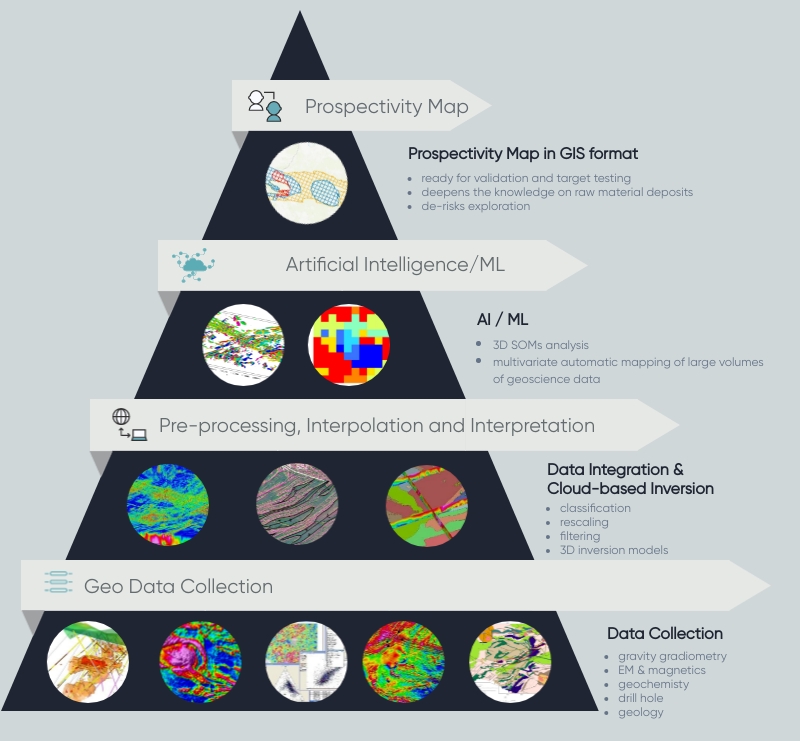
1. Inversion of the reprocessed FTG and magnetic data over the entire survey area to create 3D models as well as Self Organising Maps (SOMs) using Magnetization Vector Inversion (MVI)
2. Multivariate statistical analysis and AI over the focused AOI using FTG, magnetic electromagnetic, geochemistry, geology and drill hole data.
The Project Deliverables
The deliverables are to be used to visualise the best places for mineral exploration. They should appeal to multi-disciplinary skill sets across organisational departments
- FTG processed datasets using the latest workflows
- 3D voxels of gravity and magnetic data
- Mineral Prospectivity maps in GIS format
- Workflows manual to support further research
- Ongoing collaboration with all partners

